Cameras & Geospatial Video

SWESystem Explore 300
The Explore 300 houses a 12 MPIX Nikon D300 for oblique images. The camera is fixed in a 30-45 degree position allowing the operator to center the structure in the image viewer and insuring a minimum of 60% image content coverage for each structure photo. At the same time, a Sony FCBIX-11 Digital Video camera (10X zoom) is recording the ROW. All images and videos are geo tagged with the latitude/longitude coordinates as well as the time and date of capture. The video capture is equipped with voiceover technology when special feature coding is needed.
The Explore 300 houses a 12 MPIX Nikon D300 for oblique images. The camera is fixed in a 30-45 degree position allowing the operator to center the structure in the image viewer and insuring a minimum of 60% image content coverage for each structure photo. At the same time, a Sony FCBIX-11 Digital Video camera (10X zoom) is recording the ROW. All images and videos are geo tagged with the latitude/longitude coordinates as well as the time and date of capture. The video capture is equipped with voiceover technology when special feature coding is needed.

FLIR ThermaCAM SC 3000
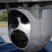
The ThermaCAM SC 3000 Infrared Camera is a gyro-stabilized infrared precision temperature measurement system, which is capable of performing infrared acquisition services for power lines, over land and water. Its spatial resolution (IFOV) is 1.1 mrad with a Thermal sensitivity of 20 mK at 30 o C and a Spectral range of 8 to 9 μm. In addition, RotorWorks uses a DayCor SUPERB corona camera for UV inspections. The DayCor system has a UV sensitivity of 3x10-18 watt/cm2 enables corona detection and emission as weak as 1.5pC at a distance of 26 feet.
The ThermaCAM SC 3000 Infrared Camera is a gyro-stabilized infrared precision temperature measurement system, which is capable of performing infrared acquisition services for power lines, over land and water. Its spatial resolution (IFOV) is 1.1 mrad with a Thermal sensitivity of 20 mK at 30 o C and a Spectral range of 8 to 9 μm. In addition, RotorWorks uses a DayCor SUPERB corona camera for UV inspections. The DayCor system has a UV sensitivity of 3x10-18 watt/cm2 enables corona detection and emission as weak as 1.5pC at a distance of 26 feet.